
Both paper and electronic nautical charts are produced in Finland, by the Finnish Transport and Communications Agency.
Printed nautical charts are produced according to the international (INT) symbology. The chart symbology is based on the international standard S-4 of the International Hydrographic Organization (IHO). You can familiarize yourself with the standard on the IHO website. The nautical chart publication Chart 1 (Marine chart symbols) explains all the symbols and abbreviations used on nautical charts.
Below is a link to the symbols used on Finnish nautical charts and a link to IHO's international standard S-4.
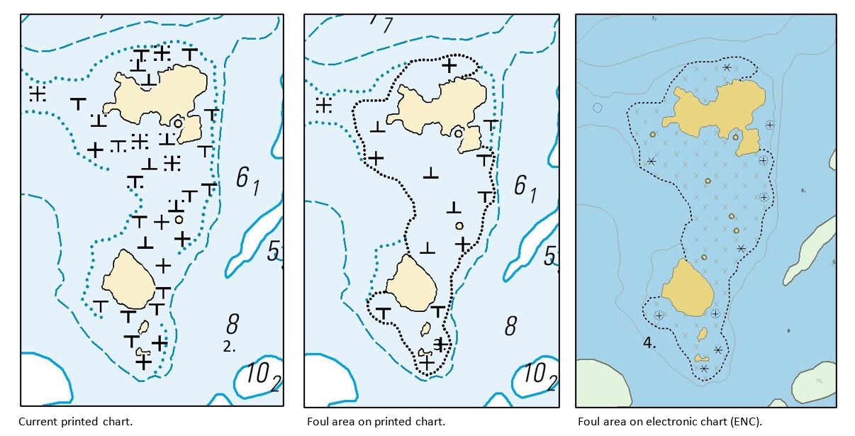
The new way of illustrating rocky areas on nautical charts eases safe navigation
The Finnish nautical charts include multiple different symbols for rocks. Beside the single symbols a new symbol has been introduced to represent widespread foul areas. These areas are very rocky and navigating within these is very risky.
The new way of illustrating foul areas will reduce the number of rock symbols and the charts will be clearer and easier to read. However, the new chart symbol will not completely replace the use of single stone symbols.
The foul area symbology is based on international nautical chart symbology. A foul area refers to an area where all dangers to navigation are not charted individually. Navigation through the area may be hazardous (IHO S-4, B-422.9). The foul area is outlined with a danger curve, a black dotted line (IHO S-4 B-420.1). It should be noted that the danger curve can be used to illustrate different types of obstacles for mariners, a symbol within the danger curve indicates what kind of danger is present in the area.
From a navigation safety point of view, the new symbology makes it clearer to mariners which areas are rocky and hazardous to navigate. The new area symbol also supports the use of chart plotters as risks related to over-zooming of the chart data, such as distortion of individual rock symbol positions are reduced. When navigating in an area which is illustrated as foul area on the nautical chart, special care should be taken!
The new symbology will be introduced on charts with the N2000 chart reform starting with the Bothnian Sea charts (chart folio E).
For more information, contact charts@traficom.fi
Coordinate system
The coordinate system of Finnish nautical charts, EUREF-FIN, is based on the international maritime standard WGS 84 coordinate system, which is also used by the GPS satellite system. EUREF-FIN aligns with the WGS 84 coordinate system with an accuracy of about one meter, so in practical navigation, the difference between the coordinate systems does not need to be taken into account. In the list of lights, all coordinates are presented only in this system.
In Finland's inland waters, there are still a few chart products produced before 2003 that are based on the national mapping coordinate system (KKJ). The reference ellipsoid is the international reference ellipsoid INT 1924 (Hayford 1910). The WGS 84 coordinate system used by the Global Positioning System (GPS) satellite navigation system differs from the KKJ system. These charts are identified by their green color. New charts are blue. On the old green charts, the light identifiers are presented with Finnish and Swedish abbreviations.