
Finnish Transport and Communications Agency, Traficom will gradually introduce the reference system N2000 in its nautical activities. Step by step, mariners and boaters will become familiar with the new system through various products and services.
How will the transition be carried out? What are the benefits of introducing the new system?
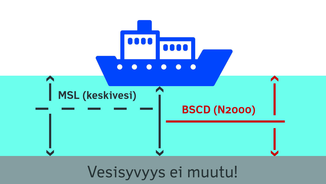
The transition means that depth and channel data will now be reported in the reference system N2000 measured from the earth’s crust, whereas the previous systems have been based on the mean sea level and the NN system. This change harmonises and clarifies the nautical charts and channels and takes land uplift into account. It also improves the safety, efficiency and profitability of the maritime sector.
The need for renewal is based on both regulations and practical issues. JHS Public Administration Recommendation 163 defines the reference system N2000 as the Finnish nationwide reference system. The system is compatible with the European EVRS reference system. The hydrographic offices in the Baltic Sea region have agreed on adopting the common reference system, which they have named Baltic Sea Chart Datum 2000. On Finnish nautical charts, the abbreviation, BSCD (N2000), will be used.
A common reference system facilitates joint use of data both nationally and internationally.
What is changing? And to what degree?
In sea areas, the extent of changes will vary depending on the area. In practice, for example, the depth data of nautical charts will in some cases decrease by as much as 60–70 cm, since the land uplift will also be taken into account. The authorised draught in channels may decrease 0–20 cm depending on the area and channel. This change will not affect depth or channel data of inland waterways, since the N2000 value selected as the height of the reference level is almost the same as the height of the reference level in the current NN reference system.
What should be taken into account? How does this change affect mariners and boaters?
From now on, mariners and boaters will need to pay more attention to the Finnish Meteorological Institute’s real-time water level observations and the forecasted water level at coastal stations. In practice, this means that the water level figures in the N2000 system will be higher than before. Thus, in the new system the importance of water level data will be stressed when determining the safe draught of the vessel.
The same authorised draught as in the current system will be achieved when combining the authorised draught and water level data. In reality, the water depth remains the same.
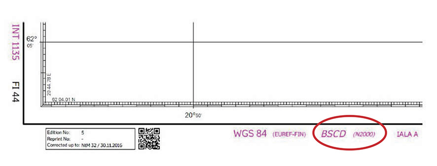
The new reference system will be introduced in the nautical charts starting in 2020 and the expected transition period is 6–8 years. The applied reference level will be indicated in the upper left margin of each nautical chart. Moreover, in order to facilitate the transition to the new reference system, the abbreviation of the applied reference system will be indicated in the lower left margin of the nautical chart. The abbreviation MSL will be used for charts on which the depth data has been measured from the Mean Sea Level, and the abbreviation BSCD (N2000) will be used for charts whose depth data is indicated in the N2000 system. In chart folios, the reference system will be marked on the inside of the front cover.
For this reform, the hydrographic and channel data have to be modified and new nautical charts published. More information about the progress will be provided at a later date.
Enquiries:
Project Manager Janina Tapia Cotrino,
Finnish Transport and Communications Agency
phone 029 534 6756
janina.tapiacotrino(at)traficom.fi
Bay of Bothnia, the Quark and Northern Sea of Bothnia, merchant shipping channels and ports,
Senior Inspector Jarkko Hirvelä,
Finnish Transport Infrastructure Agency,
phone +358 29 534 3384
jarkko.hirvela(at)vayla.fi
Archipelago Sea, Southern Sea of Bothnia, Sea of Åland, Gulf of Finland and merchant shipping channels and ports,
Head of Unit Simo Kerkelä,
Finnish Transport Infrastructure Agency,
phone +358 29 534 3354
simo.kerkela(at)vayla.fi
Entire Finland, shallow waterways,
Senior Inspector Sami Saarela,
Finnish Transport and Communications Agency Traficom
phone +358 29 534 6169
sami.saarela(at)traficom.fi