
The information content of S-57 ENCs consists of objects and attributes. Objects usually depict real-world objects, while attributes provide information on the features of the object.
The main objects used to present channel information are:
- ”Two-way route part” (TWRTPT), which depicts the channel area
- ”Recommended track” (RECTRC), which depicts the centerline of a channel
- ”Swept area” (SWPARE), which depicts a swept area
The features of a channel are described using attributes attached to the aforementioned objects. All of the above-mentioned objects have the attribute ”Depth range value 1” (DRVAL1), which is used in Finland to provide both channel depth and draught information. S-57 ENCs do not support the separate presentation of draughts. One of the aims of the change is to harmonise the use of the aforementioned attribute with the S-57 ENC standard and international practices. Compliance with standards will become increasingly important with the introduction of upcoming digital S-100 products. As part of the change, the aim is to also make more information available on channels in the form of nautical publications, for example.
Current situation
In current S-57 ENCs, channel areas are depicted using the object TWRTPT. The swept depth of some channels is provided in the DRVAL1 attribute of a separate SWPARE object, while the design draught of the channel is provided with the DRVAL1 attribute of the TWRTPT object. The channel centerline is depicted with the object RECTRC. The design draught of the channel is also provided with the DRVAL1 attribute of the RECTRC object.
Situation after the change
After the change, the object SWPARE, (used to present a swept area), will no longer be used on S-57 ENCs to encode channel information. Channel areas will only be depicted with the object TWRTPT. The DRVAL1 attribute of the TWRTPT object will be used to provide the minimum depth of the area. The DRVAL1 attribute of the RECTRC object, which depicts the channel centerline, will be left empty for class1 and 2 channels.
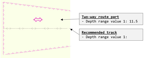
After the change, channel information for class 1 and 2 channels will be presented in accordance with the figure above (below) on all S-57- ENC cells. The structure of the presentation corresponds to that of printed charts, in which the minimum depth of a channel area is presented as a feature of the area. For shallow channels, design draughts are provided as a feature of the channel line (RECTRC), as before. For class 1 and 2 channels, design draughts will no longer be provided on N2000-nautical charts. However, until replaced with corresponding N2000-charts, mean sea level charts will also provide the design draught information in a separate INFORM field.
Changes in INFORM additional information fields
The additional information fields (INFORM) attached to TWRTPT objects are also changing. The old text is being removed. (Old text: “Maximum draught indicated in the Depth range value 1 fields of this Two-way route part and the related Recommended track MAY[NOT] be exceeded in this channel. See FTA Guideline 4955/1021/2011”.)
INFORM on N2000 charts
On N2000 charts, the information previously provided in the INFORM field will be replaced with a web link. The web link will point to a location that provides additional information related to the part of the channel. The same additional information will also be published in a separate nautical publication so that accessing the information does not require a persistent internet connection.
INFORM on mean sea level charts (MSL)
Since the change in the presentation of ENC S-57 channel information will be carried out in a few months for all Finnish sea areas, the change will also affect current mean sea level ENC-charts (MSL). On MSL charts, the design draught information removed from the RECTRC object, which depicts the channel centerline, will be moved to the INFORM field. (New content, e.g.: ”Design draught 10.0 m”). In other words, this value will still be included on MSL charts, but in a slightly different location.
Transition period for the change in S-57 ENC channel information
Changes to the encoding of channel information in S-57 ENCs will be carried out as regional sets. The work has been completed for sea areas, and changes concerning inland waterways (Lake Saimaa) will be carried out during spring 2022.
During the transition period, ENC cells using different encoding of channel information may be simultaneously present in ECDIS devices, requiring special attention by the mariner. The progress of the reform can be followed at https://fiho.fi/npub/enc_index.pdf (External link)
More info
Additional information of the presentation of channel information in S-57: Mikko Hovi, mikko.hovi(at)traficom.fi, +358 29 534 6730
N2000 fairway and nautical chart reform improved (External link)