Interference affecting mobile communications and satellite navigation services continues in Finland
In spring 2026, interference affecting satellite navigation (GNSS) and mobile networks, as well as related observations recorded by Traficom, have increased. GNSS interference is observed particularly in aviation around the clock in southern and central Finland. Disruptions to mobile communications have a localised impact in south-eastern Finland near the eastern border, and disturbances may also occur during the daytime. Traficom has submitted new interference reports concerning GNSS and mobile networks to Russia.
The Finnish Transport and Communications Agency Traficom is a national authority responsible for spectrum management, transport safety and secure communications in Finland. In this role, Traficom monitors the development of interference affecting GNSS and mobile networks, as well as the functioning of these services in Finland, on a daily basis through spectrum monitoring and interference reports. Traficom produces a national situational picture and supports preparedness, disruption management and decision-making in cooperation with other authorities. Interference affecting GNSS and mobile networks continues, and the number of interference observations recorded through Traficom’s spectrum monitoring has increased in eastern Finland since the beginning of the year.
“Maintaining situational awareness and active monitoring are essential for anticipating disturbances, managing their impacts and ensuring effective preparedness. We engage in close cross-sectoral cooperation, particularly with ministries and authorities responsible for security, and share up-to-date information on interference and disturbances to support decision-making,” says Suvi Juurakko-Lehikoinen, Head of Department at Traficom.
GNSS interference does not generally affect ground-level operations
GNSS interference particularly affects aviation and maritime transport, where GNSS systems are widely used for navigation. In addition to positioning and navigation, GNSS provides timing information which is used, for example, for time synchronisation in communications networks. In Finland, mobile networks rely on their own secured synchronisation arrangements, which are supplemented by the GNSS signal. For this reason, GNSS interference has not affected the operation of mobile networks in Finland.
At ground level, the GNSS interference situation is normal, meaning that disruptions caused by interference do not typically occur, as the effects of GNSS interference diminish rapidly due to terrain, vegetation and buildings. However, at ground level, GNSS disruptions may occur locally in areas very close to the eastern border or in coastal areas of the eastern Gulf of Finland. Interference may also affect drone operations further inland.
Figure 1 shows the main areas affected by GNSS and mobile network interference.
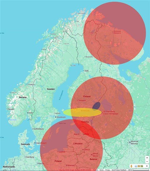
Figure 1. Areas where GNSS and mobile network interference is observed. The areas marked in red indicate GNSS interference observed in aviation at cruising altitude (10 km), where interference is detected daily. At lower flight altitudes, the affected areas are smaller. The area marked in yellow indicates the impact on maritime transport, where interference is concentrated in the eastern part of the Gulf of Finland. The blue ellipse represents the area affected by interference observed on mobile network frequencies.
Mobile network disruptions may also occur during the daytime
In areas near the eastern border, particularly between Lappeenranta and Vaalimaa, localised radio interference may still occur in mobile networks. Previously, disruptions were mainly observed at night, but according to the latest measurement data, they may now also occur during the day. For users, interference may appear as dropped calls or failed connection attempts. However, the disruptions are geographically limited and do not affect network functionality elsewhere in Finland.
“It is important to recognise the possibility of mobile network disruptions, particularly in border areas. Although disruptions are often localised and short-lived, they may occur at different times of the day. In an emergency, if there is even a single functioning mobile network in the area, an emergency call will automatically be routed through it, even if the user’s own operator’s network is unavailable. Emergency text messaging is also available,” says Juurakko-Lehikoinen.
Increase in GNSS interference observations and reports
In spring, the number of interference observations and reports also typically increases as weather conditions become more favourable for radio wave propagation, allowing radio interference to be detected even at considerable distances from its source. This phenomenon is known as good radio propagation conditions.
“Overall, interference can be said to have increased during spring 2026. In our spectrum monitoring, the number of GNSS interference observations has risen clearly since February 2026. In some areas, observation levels have been exceptionally high, and spoofing has also been detected,” says Juurakko-Lehikoinen.
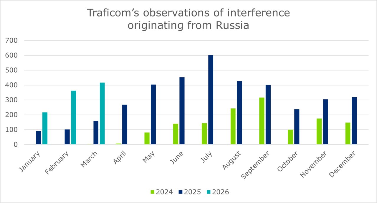
Figure 2. GNSS interference observations recorded by Traficom’s spectrum monitoring in areas surrounding Finland during the spring. A higher number of interference observations have been recorded, particularly in March 2026. (Note: The increase is partly explained by the development of the monitoring system during 2024–2025, meaning that year-on-year figures are not directly comparable.)
The increase in interference has also been reflected in a rise in GNSS interference reports during spring 2026, particularly in aviation. Interference is also regularly observed and reported in maritime transport. As the boating season begins, it is advisable to be prepared for disruptions in the Gulf of Finland. Chart plotters should therefore not be relied on blindly and a paper chart should be carried on board.
“Interference affecting both mobile network and GNSS frequencies originates from Russian territory. It is linked to Russia’s so-called self-protection jamming, which is used to protect its critical assets,” Juurakko-Lehikoinen says.
Traficom has submitted new interference reports to Russia and the ITU
In April 2026, Traficom submitted new official reports on interference affecting GNSS and mobile network frequencies to Russia and the International Telecommunication Union (ITU). These reports are part of an international procedure through which radio frequency interference is addressed between states.
Traficom's reports are based on measurement and observation data produced through spectrum monitoring, describing the temporal and geographical occurrence of interference. The aim of the reports is for the source of the interference to take measures to eliminate or mitigate it. The reports also contribute to the ITU’s overall situational awareness of interference.
“Although our spectrum monitoring does not indicate the intent behind the interference, it provides a reliable picture of its extent and development. International interference reporting is a key element of cooperation between authorities in the event of disruptions,” says Juurakko-Lehikoinen.
Preparedness is key to managing the impact of GNSS interference
GNSS interference may particularly affect navigation and positioning in aviation, maritime transport and boating, and in border areas also the operation of drones, for example. However, the impacts are generally localised.
In critical GNSS-dependent systems across society, preparedness for interference is ensured through multiple parallel solutions. In aviation, several alternative navigation methods are available, ensuring that flight operations remain safe. In communications networks, where the GNSS signal is used for time synchronisation, the risk of interference has been recognised and mobile network systems are designed to withstand even prolonged GNSS disruption without significant impact on services.
Although GNSS and mobile network interference continues, essential public services and critical infrastructure continue to function well. Preparedness is ensured at national level through multiple parallel solutions, and the authorities continuously monitor the situation.
“This is how we ensure that society continues to function even in the event of disruptions,” Juurakko-Lehikoinen emphasises.
Monitoring of and preparedness for GNSS and mobile network interference form part of Finland’s comprehensive security and security of supply. Within this framework, Traficom acts as a centralised expert authority and provider of situational awareness, supporting the preparedness of other authorities responsible for security, businesses and other stakeholders.
Traficom will continue to monitor the interference situation, carry out additional measurements where necessary, and maintain and share an up-to-date situational picture across different branches of government to support decision-making by authorities, companies and other stakeholders.
Enquiries
Suvi Juurakko-Lehikoinen, Head of Department, tel. +358 29 534 0326, suvi.juurakko-lehikoinen @traficom.fi
Satellite navigation service interference in Finland Ulkoinen verkkopalvelu.
The redundancy of communications networks is governed by Traficom Regulation 54, which requires network synchronisation to a reference clock system located in Finland, and the network must be capable of withstanding at least two weeks of GNSS disruption: Regulation on resilience of communications networks and services and of synchronisation of communications networks Ulkoinen verkkopalvelu.